Tracking ships around the world in real-time.
Monitoring. Search. AIS Data.
Current Traffic
-
 Vb Muscle
7sec agoarrived inCastellon de la Plana
Vb Muscle
7sec agoarrived inCastellon de la Plana
-
 Steenbank
26sec agoleft
Steenbank
26sec agoleft Rendsburg
-
 Esme Timbery
26sec agoleftSydney
Esme Timbery
26sec agoleftSydney
-
 Horizon 9
27sec agoarrived in
Horizon 9
27sec agoarrived in City of Singapore
-
 Breydel
27sec agoarrived in
Breydel
27sec agoarrived in Lagos
Lagos
-
 Poeta Lopez Anglada
29sec agoleftAlgeciras
Poeta Lopez Anglada
29sec agoleftAlgeciras
-
Nar-Dha
30sec agoleftBrisbane
-
 Protoporos XIII
39sec agoarrived inPerama
Protoporos XIII
39sec agoarrived inPerama
-
Walter
40sec agoleftCologne
-
 Chad Douglas
41sec agoleftNew Orleans
Chad Douglas
41sec agoleftNew Orleans
Search and Track Positions of Ships in Real-Time
AIS Monitoring
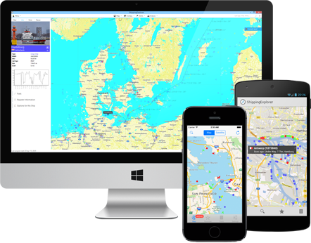
ShippingExplorer uses AIS data (automatic identification system) to determine positions and provide exhaustive information about ships. Based on AIS, our system builds a map of ship movements in real-time on seas and oceans and allows for locating and detailed monitoring of ships and ports.
Map with AIS Data
Our application has several map providers and color schemes to show AIS data. Additional layers with information about weather, waves, and wind are available.
Route Planning
ShippingExplorer offers the tools to plan routes with ETA in ports and bunker calculations.
Locate Ships in Real-Time
The program allows to search for ships based on a variety of criteria (by name, MMSI, IMO, type, register information, destination, etc.). For example, allowing you to see all passenger ships headed to Lisbon.
Alerts
We have a flexible configuration system for notifications via SMS and e-mail for tracking ship positions and behavior in real-time. For example, you can be notified when your ship enters a specific area, changed its speed or course.
Archive
Besides positions of ships on our maps in real-time, ShippingExplorer has archived information about ships for several years.
 Noorderlicht


